in the news (145)


NATURE PLAY
0 layout(s)

february 2013 | by linda repplinger | show project

We spread out through the snowy forest, walking from one exposed patch of ground to another. Hunters and gatherers.

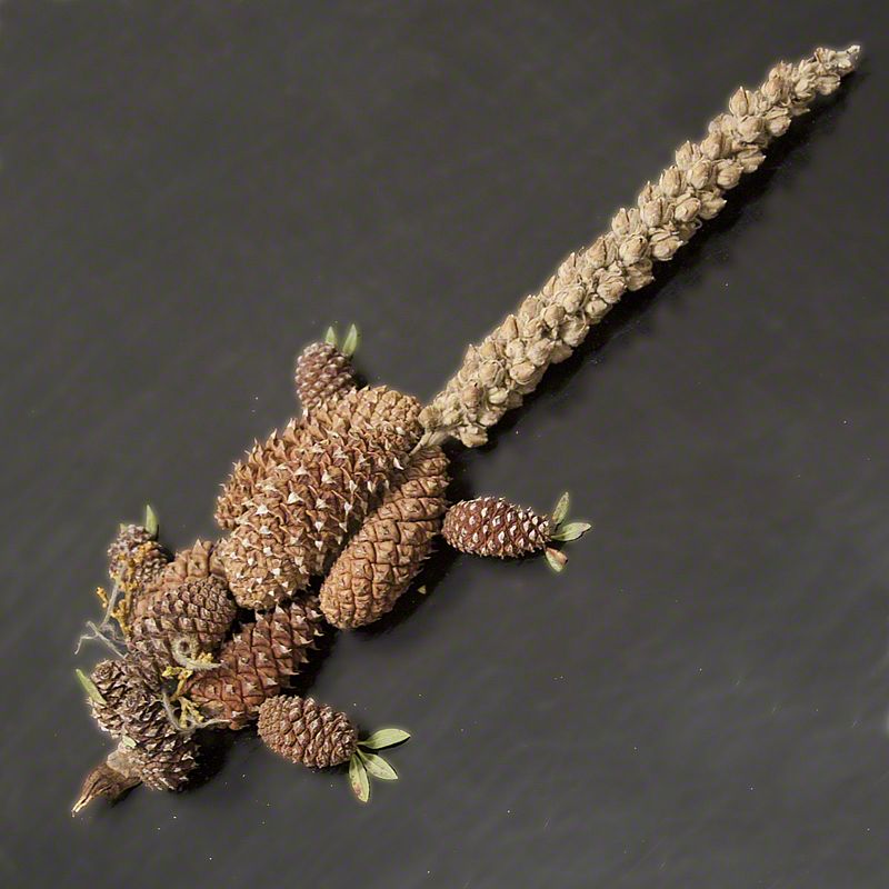
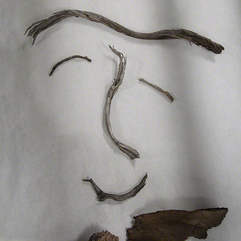
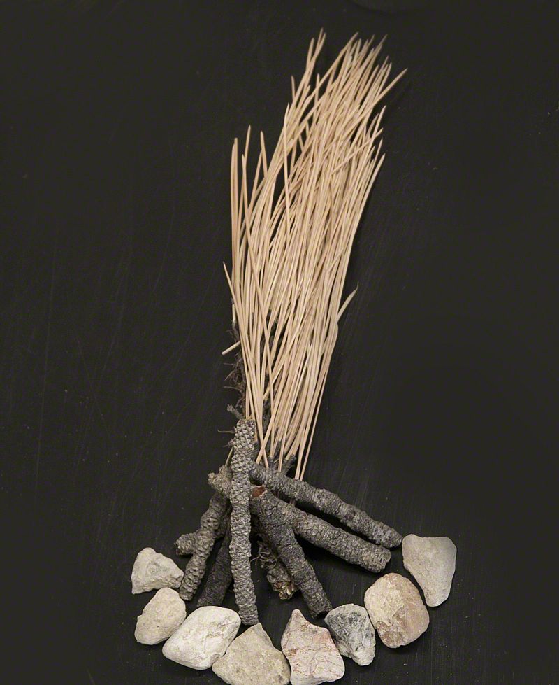
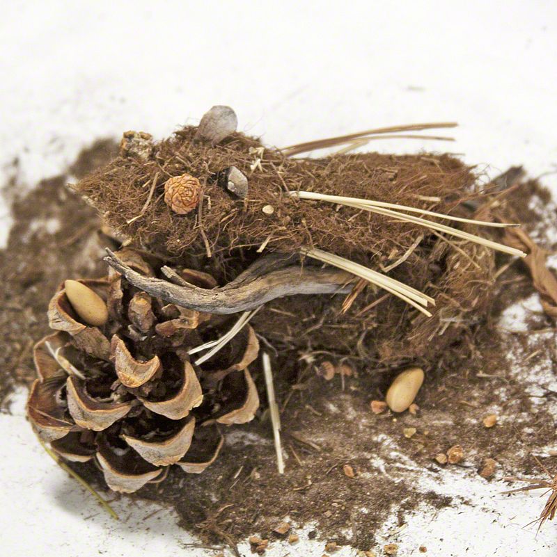
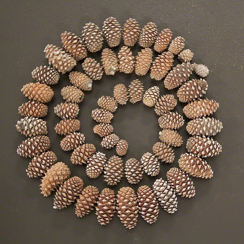
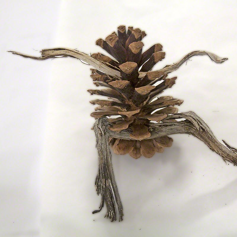
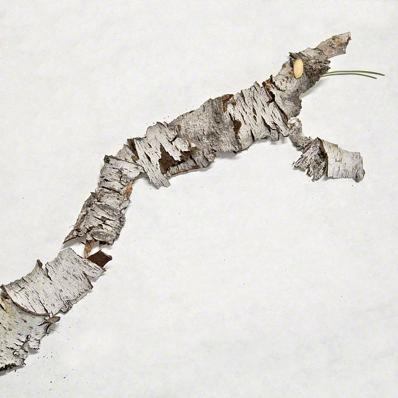
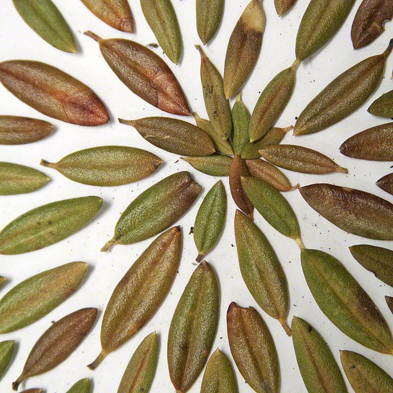
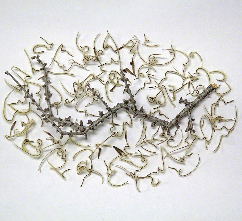
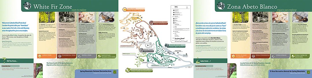
"You've got to see this over here!" Nancy calls. "Hold that spot!" Susan shouts back as she gathers one more handful of pinecones into her box before making her way over to Nancy. As we wander, searching for interesting patterns and colors, we see the ordinary with new eyes - orange colored puzzle pieces from ponderosa pine bark, feathery mountain mahogany seeds, silver scaled pinyon pine branches, dark loamy piles of decaying fir needles. As artists selecting paints in a palette, we fill our boxes with these treasures. We are preparing to use these materials to create artwork from nature in an exhibit for the Spring Mountains outside Las Vegas.

Back at Sea Reach, the staff gathers together to play. We hope to inspire others to let go of modern entertainment for a while and become kids playing with twigs and pinecones!

PICNIC ANYONE?
3 photo(s)
0 layout(s)

february 2013 | by alex ogle | show project

For months, our designers have been finessing the layouts for eighty-five (85) exhibit panels. These six-foot-long exhibits will be inlaid into concrete picnic tables in the newly renovated Cathedral Rock Picnic Area in the Spring Mountains National Recreation Area. When the project finally reaches print pre-press (my area), the general manager and I sit down to review the timeline. I can feel my blood pressure rise. Seemingly, no one was thinking about how long it would take to get 85 exhibits through production. We put the calendar in front of us: how much time do we need to run final color tests, prepare files for printing, print, proof prints, embed prints, QC embedments, tally and organize, package for shipping, ship, receive and install - as we forecast the tasks and we quickly realize, we do not have enough time to meet our installation date. Houston, we have a problem.

We gather the business together and re-examine our process. Each person identifies a more efficient way to perform a task. All together, we feel we can improve the timeline by a couple of weeks - giving us some wiggle room and ensuring that we can meet our deadline.

MOUNTAINS TO SOUND GREENWAY TRUST
1 photo(s)
0 layout(s)
1 document with 1 pages

february 2013 | by heather julius | show project

I was happy to hear of Obama's pick for the new Secretary of the Interior: Sally Jewell, the current CEO of REI and former President and Founding Board Member of Seattle-area conservation group, Mountains to Sound Greenway Trust. At the mention of Ms. Jewell's connection to Mountains to Sound, I recalled the important role that volunteers from this organization played in the restoration work at Lake Sammamish, where we are working on a project for Washington State Parks.

We are designing beautiful exhibits that will be installed along the new boardwalk at the mouth of Issaquah Creek. Visitors to Lake Sammamish State Park will learn about the restoration efforts of the 1,251 volunteers who contributed nearly 5,000 hours to restore areas along the lakeshore and the banks of Issaquah Creek. I am impressed by the leadership, vision and generous spirit of the Mountains to Sound Greenway, and hence an admiration for our new Secretary of the Interior.

RED CANYON HIERARCHY
6 photo(s)
0 layout(s)

february 2013 | by nicole adsit

Nestled along Highway 12 in the Dixie National Forest, Utah, Red Canyon is exactly that: red!. Huge red rock formations thrust from the ground creating a vibrant and dynamic landscape. Within Red Canyon visitors can mountain bike gravel trails, navigate the canyons on horseback, speed past scenery on OHVs, hike the ridges on foot, or seek solitude in a dispersed campsite. Sea Reach is creating a set of exhibits at the Red Canyon Visitor Center to help users navigate the area specific to the recreation of their choice.

With all the recreation available to visitors it was necessary for us to establish a visual hierarchy within each exhibit. Visual hierarchy refers to the organization of information through color, font size, and composition. We found it very important to incorporate a structured composition on each exhibit so that visitors would know where to find pertinent information, such as map, trail description and elevation graphs. A project like this is beyond exhibit design, it is Information Architecture.

BLOB TAXONOMY
0 layout(s)

february 2013 | by melissa boettcher | show project

Sea Reach is rounding a corner to completion on the final phase of the new comprehensive wayfinding plan for Hoyt Arboretum. The next phase is to update the existing collections exhibits and add ten more.

When I was given this assignment, I noticed that the old exhibits had a series of undefined "blobs" to demonstrate tree shape and size. I made it my mission to create better blobs with a well-defined shape and structure for each tree family. After a thorough search of the Arboretum's online photo collection - I looked closely at the architecture of each tree. I traced the trunk and branches and removed aberrant or abnormal branches to establish the "typical" shape for each tree type. After the "skeleton" of the trunk and branches is drawn, then a basic, amorphous shape or "blob" is applied to give the tree shape. These help a visitor to identify tree types within a family with just a glance at their basic profile. The exhibits feature up to 6 different shapes and sizes within a specific tree family.

CORDOVA AIRPORT
0 layout(s)

february 2013 | by susan jurasz

There are no roads into Cordova, Alaska. The airport, typical of many of the airports in Alaska, is small and unassuming. This is the gateway into one of the most specular places in the world: Prince Williams Sound, the Chugach National Forest, and the Copper River Delta. The Copper River Delta extends for 700,000 acres (2,800 km2) and is considered the largest contiguous wetlands along the Pacific coast of North America. The delta is used annually by millions of birds, including the world's entire population of western sandpipers; the largest nesting population of trumpeter swans and the only known nesting site for the dusky Canada goose. Over 2 million salmon spawn here each year. And as if that is not enough: two glaciers, the Miles and Child's glaciers calve directly into the river.

Sea Reach is working with Alaska Airlines and the US Forest Service to design, fabricate and install a mural that wraps the interior walls of the Cordova Airport. The mural reflects roughly 100 miles of coastline with fishing boats, past the mountain ranges and glaciers to the Copper River Delta. It highlights the stunning scenery that surrounds Cordova, including the Chugach National Forest and the Copper River Delta.

CROSSROAD
5 photo(s)
0 layout(s)

january 2013 | by linda repplinger | show project

The old brick bank building sits at a crossroads in time - once the site of a train track where pioneer farmers transported hard red winter wheat from the fields to towering grain elevators, it is now the route of the Sheyenne River National Scenic Byway. Seeing the old building surrounded by miles of farmland reminds me of my grandma's stories about growing up in North Dakota.

The building was constructed in 1916 as Kathryn's bank and served as one for many years before going into receivership during the Great Depression. Through the years, the building housed a creamery, a grocery store with a lunch counter, and a furniture store before it was abandoned and began to decline. Today, the building is being restored as a meeting hall and visitor center with new graphic displays. After nearly 100 years, the building still has its original tile work at the front entrance, a state-of-the art 1900s burglar alarm, and a vault with 2-foot-thick walls.

A SMALL WORLD
1 photo(s)

january 2013 | by megan whitaker | show project

Obituaries and interpretive exhibits don't have an immediate connection, but for me, a newspaper obituary can represent the turning point in my quest to find images for an exhibit. At the newly renovated Mahogany Grove Group Campground in the Spring Mountains National Recreation Area each campsite is being named after a person notable in the development of the area. And my current quest is to find photos of a gentleman called B.V. Smith.

I begin my search with nothing more than B.V. Smith-not even a first name! I become the Nancy Drew of obituaries, census records, and Ancestry.com. Fortunately, I knew that he lived in the Las Vegas/Mt. Charleston area during the 1930s. After days of combing the internet, I began to piece together a family tree. Phone calls and messages go out to prospective living family members explaining why I needed to speak with them about their grandfather. Imagine my surprise when I found his granddaughter lives just 20 miles away from me in McMinnville, Oregon and has photos I can scan. The family of Benton Van Buron Smith is pleased to discover that their grandfather is being honored for his contribution to the Mt. Charleston area.

LOWER ROGUE RIVER WATERSHED
0 layout(s)

january 2013 | by nicole adsit

On the southwestern coast of Oregon lies the charming beach town of Gold Beach. It's there that the magnificent Rogue River meets the even more majestic Pacific Ocean. The region is defined by the vital watershed of the Rogue and is home to a variety of fish and wildlife that have been a resource for the peoples of Southern Oregon for thousands of years.

Sea Reach is working with the Lower Rogue Watershed Council to give new life to a series exhibits we produced nearly twenty years ago, on display outside the Lower Rogue Watershed Council Building. The new design emphasizes the vitality and fluidity of the watershed - full of soft greens, yellows, blues and purples. The panels will showcase information on the wetlands, wildlife, plant life, early peoples, fish found in Lower Rogue and information on the scenic byway route.

60-TON ICEBERGS ROARING AT 65 MPH
2 photo(s)

january 2013 | by heather julius | show project

My friends and I are out at dinner trading war stories. Er, work stories. I've got a good one: "Imagine," I say, "a giant ice dam blocking a river in the panhandle of Idaho around 18,000 years ago. A glacial lake containing 10 times the flow of all the rivers in the world forms behind this dam. Then, the dam breaks, and the resulting flood, filled with boulders the size of houses and 60-ton icebergs roar at speeds of 65-miles-per-hour over16,000 square miles, across four states, including Oregon, in a thick slurry of mud. Gouging and scouring the land as it speeds by."

My friends don't believe it. But it's all true! And that's not all! This all happened during the time when Ice Age mammals, like 10-foot-tall sloths, roamed the area.

Our challenge is to connect people with a past too wild to believe - one that took place in our backyards. The Tualatin Ice Age Discovery Trail, designed to be a local and pedestrian-friendly complement to the National Park Service "Ice Age Floods Geologic Trail," is in the planning phase. As Sea Reach's research and writer, I am becoming a believer.

left left
showing
left left